Remote sensing satellite applications in agriculture
Introduction
Incredible as it may seem, agriculture – the most traditional and oldest sector of human activity – is one of the main customers and consumers for the whole range of complementary earth remote sensing services, including space monitoring technologies and unmanned devices or drones. Whether we like it or not, the advancement of technology does not stand still, so everyone should seize the moment and start using them in their area.
Combined aerospace monitoring has four main components:
surface sensing
multispectral survey of agricultural land
guaranteed daily control
monitoring of data processing systems.
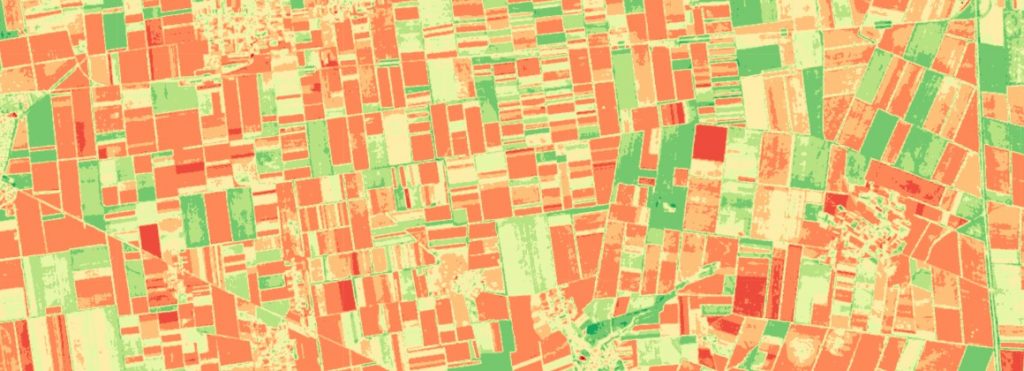
It must be remembered that we are not just talking about taking snapshots on the fly, but going beyond the range of the human eye, as we gain access to information in the infrared domain. The world looks very different at these wavelengths. Humans are only slightly sensitive to these rays, sensing them as heat waves, but nothing more. Satellites, however, interpret them accurately and construct beautiful images that reveal nature’s unseen secrets. The true state of crops becomes evident with the help of vegetation indices, especially the Normalised Difference Vegetation Index (NDVI).
Undoubtedly, we are talking about a very complex and sophisticated system based on integrated efforts from many sides: satellites take pictures of fields and land, then professionals analyse these images, contrast them with the local situation and make their conclusions from which databases are compiled and in the end all this takes the form of programmes, instructions and recommendations applied to the agricultural sector.
Why has all this suddenly become necessary for agriculture?
Previously crops were grown without any space technology, however, with the development and implementation of precision agriculture the range of useful information has expanded significantly. Once the information is received from remote monitoring, precision farming uses the data for differentiated fertiliser application, plant protection, dosed irrigation, crop and yield control, and many more farming activities that ultimately save resources and reduce costs by helping to increase yields.
If we take multispectral analysis as an example, it allows us to determine the condition of plants and therefore detect problem areas: in some cases crop distress can be caused by excessive soil compaction, erosion or drying out, in other cases the negative effect is caused by an imbalance in nutrient supply. This sounding technology also allows us to predict crop yields.
Technical aspects of crop monitoring
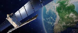
A large number of remote sensing satellites are currently orbiting the earth. The resolution of these data is very different. For example, NASA and NOAA (National Oceanic and Atmospheric Administration of the United States) satellites have a resolution of 1 km at 250 m. You can visit the NASA website https://earthobservatory.nasa.gov/ for more information. The main advantage of this type of imagery is that it covers large areas. This resolution, considered as medium, is sufficient to, for example, track the movement of air masses, cyclones, atmospheric fronts. For example, the resolution of 500 m is already sufficient to compile a soil moisture map.
Travelling around the Earth at orbital speed, satellites can scan huge areas of land and sea in a matter of minutes. In fact, a return to orbit can take less than two hours, meaning that the entire circumference of the Earth can be imaged within that time. Thanks to this incredibly wide coverage of satellite image data, crop insurance companies can accurately measure the area of a field in seconds. The data is instantly integrated into the Crop Monitoring platform, so users can see the exact contours of any selected field on an interactive map, on any screen.
Another benefit worth mentioning is higher resolution satellite imagery that allows detection of plantings and identification of crop status, among other features. Technologies allow for more detailed imagery, with smaller satellites providing a resolution of 7.8 m and less. State-of-the-art aerospace technology already offers satellite images of 0.7 m and even 0.5 m resolution. The resolution of 0.5 m is considered to be very high, the highest satellite record today is 0.31 cm. However, this image no longer covers a large territory, but a square of 10-12 km on each side.
By combining high-resolution imagery with remote sensing data, our platform provides agricultural companies with the ability to predict climate risks and assess natural and man-made damage to soil and crops. Soil moisture data helps identify flooding, while critical temperature detection allows you to recognise destructive natural events such as cold stress.
Sometimes for some agricultural needs even such detailed imagery is not enough. In addition, cloudy skies can interfere with satellite imagery. To increase the resolution to a few centimetres, photos are often taken by unmanned aircraft from low altitudes. For example, a drone takes photos from an altitude of 120 m, providing a resolution of 4.8 cm. On the other hand, flying at such a height, an unmanned aerial vehicle can fly over an area of only 130 hectares in one hour.
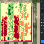
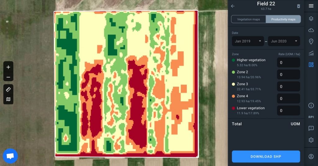
Another way to collect accurate data on the productivity of a field is to use the “zoning” function. Satellite imagery not only provides the true natural colour of the field, but also measures the Normalised Difference Vegetation Index (NDVI) in the near infrared. In other words, variations in vegetation density are captured by remote sensors and displayed on the screen creating a slightly exaggerated contrast to each other. A field appears to be divided into several zones, according to the NDVI. With this function, any agricultural company can determine not only the actual state of the crops, but also calculate the total area of more or less productive segments within a field.
What problems can farmers solve with space technologies?
Technological advances are widely systematised and farmers already have at their disposal sophisticated platforms and programmes that integrate a significant amount of incoming data. Our EOS platform offers a collection of data from 4 sources (optical satellite imagery, satellite radar imagery, aerial photo-reporting and unmanned aerial imagery) and allows image processing in the cloud for multi-purpose analysis:
terrain classification
culture monitoring;
definition of field boundaries and planted crops;
crop rotation analysis;
crop condition assessment;
vegetation maps;
soil maps;
quality control of work carried out;
rainfall;
climate and weather conditions;
crop forecasting.
The collection of information on nutritional deficiencies and the spread of pests and diseases is used to ensure differential application of fertilisers and plant protection products.
However, arguably the crucial feature that any agricultural company will benefit from is the accurate assessment of field productivity based on historical and current data as agricultural software accumulates, systematises and presents, in a comprehensible form, millions of data received from all kinds of sources.
Satellite remote sensing and country-specific problems
The EU’s Common Agricultural Policy provides subsidies to farmers and also monitors their use of subsidies. And while in the 1990s this monitoring was done by inspectors who travelled all over the farms, now the subsidy monitoring system increasingly uses remote sensing data.
In France, for example, satellite monitoring of crops has existed for more than 15 years, remote sensing of pests and cultivation processes is complemented by ground monitoring of 5% of the national territory with the help of some 1,500 people. The final result of this joint work is displayed on specialised websites and for a reasonable price farmers can receive concrete recommendations concerning their crops.
The same satellite service can deal with the chaos that sometimes exists in land cadastre data, which has become a serious problem in some countries. Based on the satellite data and images, vector maps can be created using special software.
In countries where winter crops are grown, it is essential to monitor snow cover and snowmelt over a long period of time in order to establish favourable conditions for frost-proofing of plants.
The first experience of analysing the consequences of a hurricane using space-based sensors was also obtained. This made it possible to obtain operational and, more importantly, objective information on crop damage.
Key benefits and challenges
Satellite imagery is extremely useful for all agricultural companies and serves to solve strategic tasks: forecasting vegetation conditions, determining which crops to plant and when, providing information to insurers and evaluating land. At the same time, large agricultural companies need satellite image data for autopilots and parallel driving to track farm machinery and differentiated fertiliser application.
Medium-sized agricultural companies also require spatial monitoring data for autopilots and parallel driving and, above all, for climate risk management.
And finally, small farms need spatial technologies to organise routine tasks: differentiated irrigation, fertiliser use, machine interactions, crop monitoring, land cost, technological and administrative decision making and cost optimisation.
If we take the overall investment made in land cultivation, we see that the cost of applying remote sensing technologies is a small part of the total, but it offers very important advantages:
it reduces the cost of material and technical resources involved (80% of farmers say this);
benefits the environment;
improves product quality;
increases gross yields;
optimises working conditions and safety;
saves time and labour effort;
ensures more control;
decreases insurance premiums (the cost of insurance services for the farmer).
The number of farmers who are actively implementing these technologies in their fields is growing every day, and there is already a significant number of companies that use them on a daily basis and very extensively. At the same time, the companies that develop software for agricultural platforms are constantly improving their innovative products, adapting them to the needs of all types of consumers and creating more and more practical benefits.
New technologies make life easier, save a lot of time and offer the convenience of analysing many key parameters associated with the field from home. This is all the more desirable as the situation in the world worsens every year and every opportunity to automate traditional farming processes must be seized. Farmers already using such resources are always one step ahead, and if you want to compete and make your business profitable, you need to keep abreast of developments in the agricultural area.
Therefore, it is certain that new technologies today are the key to a farmer’s success. Although at the beginning it may seem a bit expensive service, it will sooner or later become the obligatory and reliable ally of farmers all over the world, overcoming minor technical mismatches and existing problems and overcoming that too conservative approach that is still too deeply rooted among people who dedicate their lives to farming.